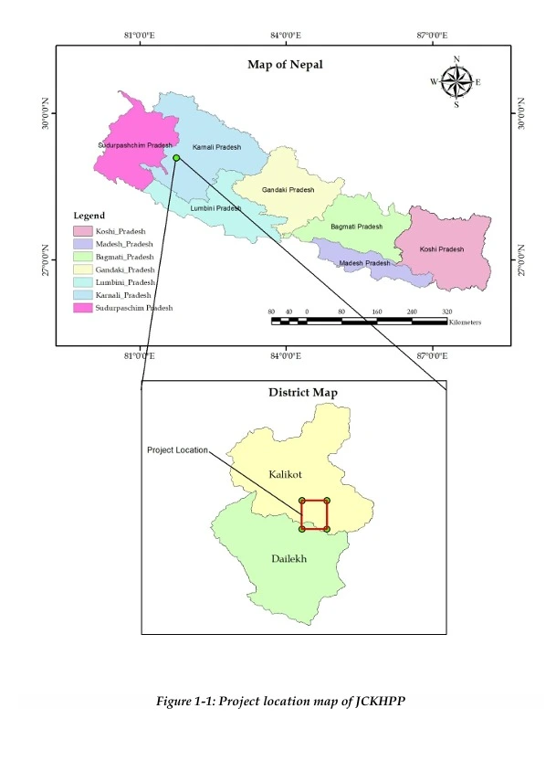
Jilli Chumli Khola Hydropower Project (JCKHPP) is a storage-type scheme located at Mahawai Rural Municipality (previously Odanakhu VDC) of Kalikot District, Karnali Province. Jilli-Chumli Khola is a tributary of Tila Nadi. Geographically, the project area ranges from the latitudes 28° 59’ 27" N to 29° 5’ 50" N and the longitudes 81° 45’ 10" E to 81° 50’ 45" E, respectively.
The proposed headworks site lies at an altitude of about 2840 m (ground level). The surface powerhouse is located on the right bank of the Jilli Chumli Khola just upstream of the confluence of the Ruru Banche Khola with the Jilli Chumli Khola near Padmaghat. It has an installed capacity of 100 MW with a design discharge of 8.33 m³/sec and a rated net head of 1573 m. 529.911 GWh of annually generated energy will be evacuated to Phukot substation at Kalikot by a 132 kV double-circuit transmission line at Phukot substation of NEA. The length of the 132 kV transmission line will be about 16 km from the project powerhouse to Phukot Substation.
SALIENT FEATURES – JILLI CHUMLI KHOLA HYDROPOWER PROJECT
|
Parameters |
Details |
|---|---|
GENERAL |
|
|
Name of the Project |
Jilli Chumli Khola Hydropower Project |
|
Name of the River |
Jilli Chumli Khola |
|
Type of Scheme |
Peaking Run-of-River |
|
Project Location |
Mahabu Rural Municipality, Kalikot District, Karnali Province, Nepal |
|
License Boundary |
Easting: 87°27’01" E – 87°30’00" E; Northing: 27°46’56" N – 27°48’29" N |
|
Nearest Settlement |
Dillikot / Baluwatar |
|
ORGANIZATION |
|
|
Developer |
Sakshyam Hydropower (P) Ltd., Nepal |
|
Consultant |
Engineering Team of Sakshyam Hydropower (P) Ltd. |
HYDROLOGY |
|
|
Catchment Area at Intake |
50.6 sq. km |
|
Catchment Area at Powerhouse |
100 sq. km |
|
Design Discharge |
8.64 m³/s |
|
Average Annual Discharge |
2.66 m³/s |
|
Minimum Monthly Discharge |
0.76 m³/s |
|
Maximum Monthly Discharge |
7.51 m³/s |
|
Minimum Environmental Release |
0.16 m³/s |
|
Flood Discharge (Headworks – 100 yrs) |
177.40 m³/s |
|
Flood Discharge (Powerhouse – 100 yrs) |
234.06 m³/s |
|
Construction Flood (20 yrs) |
39.18 m³/s |
SEDIMENT STUDY |
|
|
Average Annual Sediment Load |
171,747.1 tons |
|
Maximum Sediment Load |
0.657 kg/m³ |
|
Estimated Annual Sediment Yield |
0.221 million tons/year |
GEOLOGY |
|
|
Regional Geology |
Higher Himalaya |
|
Major Rock Type at Headworks |
Foliated gneiss with thin schist partings |
|
Major Rock Type in Waterways |
Gneiss, augen gneiss, schist, colluvium |
|
Major Rock Type at Powerhouse |
Alluvial terrace deposits, foliated gneiss |
DAM |
|
|
Type |
CFRD |
|
Full Supply Level (FSL) |
2935 masl |
|
Dam Crest Length |
215 m |
|
Lowest Riverbed Level at Weir Axis |
2893 masl |
|
Foundation Rock Type |
Foliated gneiss with schist partings |
|
Dam Height |
51 m |
|
Reservoir Volume |
63 MCM |
DIVERSION DURING CONSTRUCTION |
|
|
Construction Flood |
39.18 m³/s |
|
Diversion Type |
Cofferdam |
|
Diversion Length |
500 m |
INTAKE |
|
|
Intake Type |
Side intake |
|
Number of Orifices |
3 |
|
Orifice Size |
2.0 m × 1.5 m |
|
Top Sill Level |
2912 masl |
|
Invert Sill Level |
2910 masl |
|
Gate Type |
Fixed wheel vertical lift |
|
Hoisting System |
Gantry crane hoist |
|
Trash Rack Dimensions |
2.0 m × 1.5 m × 3 nos |
|
Clear Opening of Trash Rack |
50 mm |
|
Trash Rack Cleaning Mechanism |
Trash rack cleaning machine |
HEADRACE TUNNEL |
|
|
Type |
Inverted D-shaped |
|
Lining Material |
Concrete and shotcrete |
|
Length |
6500 m |
|
Size |
2.8 m × 2.8 m |
|
Thickness |
50–200 mm |
|
Support Type |
Concrete lining, steel ribs, rock bolts |
SURGE SHAFT |
|
|
Type |
Restricted orifice |
|
Diameter |
4 m |
|
Height |
80 m |
POWERHOUSE |
|
|
Type |
Surface |
|
Dimensions |
33.5 m × 15 m × 28 m |
|
TURBINE |
|
|
Type |
Pelton, vertical axis |
|
Number of Units |
2 |
|
Rated Capacity per Unit |
50.5 MW |
|
Efficiency |
90 % |
GENERATOR |
|
|
Type |
Salient pole synchronous |
|
Rated Output |
55 MVA |
|
Voltage |
11 kV |
|
Efficiency |
96.5 % |
TRANSFORMER |
|
|
Type |
Outdoor oil immersed |
|
Vector Group |
YNd11 |
Efficiency |
99 % |
TRANSMISSION LINE |
|
|
Voltage |
132 kV |
|
Length |
16 km |
|
Connection Point |
Phukot Substation |
POWER & ENERGY |
|
|
Installed Capacity |
101 MW |
|
Total Annual Energy |
295 GWh |
|
CONSTRUCTION PERIOD |
48 months |
PROJECT COST & FINANCIALS |
|
Total Cost (Including IDC) |
NPR 18.34 Billion |
|
Project IRR |
12.49 % |
|
Equity IRR |
17.66 % |
|
B/C Ratio |
1.24 |
|
Payback Period |
11.9 years |